


Basics
- Length:
- 16.3 miles (26 km)
- Time:
- Allow 2.5 hours with stops at the visitor center, summit, and Western Gateway Heritage State Park. Plan for 5 hours if your tour involves light hiking.
- Fees:
- No fee for access to the park. Parking at the summit lot is $2.
Description
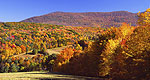
At 3,491 in elevation, Mount Greylock is the highest point in Massachusetts and southern New England. A paved road system extends up to the summit which features a fantastic panorama offering a view into five states, upwards to 70 miles distant.
This notable mountain is rich in both nature and history. Lofty slopes rise above the surrounding land, sheltering ancient stands of forest and unique habitats for plants and animals. It has been celebrated in works by noted American authors: Henry David Thoreau, Nathaniel Hawthorne and Herman Melville.
The byway also offers opportunities for hiking, camping, backpacking, overnight lodging and meals at the summit, and is close to northern Berkshire region cultural attractions.
Please note: The road system is closed to auto traffic for the 2007 and 2008 seasonsand currently under repair for safety and access improvements. This affects publicaccess to certain facilities; as a result the summit is not accessible byautomobile, Bascom Lodge and the Veterans War Memorial Tower are closed. Operationand access to these facilities are scheduled to resume in spring 2009 uponcompletion of the Historic Parkway road repairs. The Mount Greylock Visitors Centerand trails remain open.
Tourism Resources
Helpful Links
Tourism Resources
Points of Interest
Points of Interest Along The Way
Adams (MA)
Come visit this historic town, the birthplace of Susan B. Anthony.
Appalachian National Scenic Trail (MA)
Stretching over 2,000 miles from Georgia to Maine, the A.T. is one of the ultimate hiking opportunities and destinations of the United States.
Mt. Greylock State Reservation (MA)
This beautiful reserve has a campground as well as trails to hike. Mt. Greylock is the tallest mountain in Massachusetts. Many authors have recieved inspiration while gazing at this mountain, including Thoreau, Melville, and Hawthorne.
Western Gateway Heritage State Park (MA)
Explore the controversial and danger-filled story of the construction of the Hoosac Tunnel, one of the greatest railroad engineering feats of the 19th Century.
Williamstown (MA)
Home to the famous Williams College

