


")
Basics
- Length:
- 34 miles (54 km)
Description
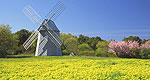
Travelers on Old King's Highway, Route 6A can see hundreds ofhistoric sites. These range from sea captain houses, to pilgrimchurches, to other historic buildings. Other points of interestinclude cranberry bogs, salt marshes, and preserved farmlands. Thelocal citizens have made great efforts to ensure that this area isclean and well preserved. Visitors will find many newly paintedhouses and yards with flowers and professional landscaping.
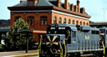
The present day byway was once an Indian trade route, traveledon for thousands of years. When the pilgrims arrived, they used itfor their carts and wagons, which widened the path. With theemergence of cars in the early 19 hundreds, the trail changed againand is now accommodated for motorized vehicles. This byway is alsowell suited for bicyclists. It often follows along the coast andpasses through 7 Cape towns. Come here to drive, bike, or walk oneof the largest historic districts in the nation.

